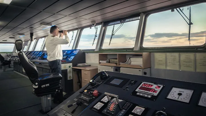
High-accuracy navigation

SafeCaptain Navigation Software
SafeCaptain is a high-accuracy navigation tool designed to enable marine captains with unparalleled situational awareness and control. Running on a portable iPad, it combines official sea charts with advanced overlays to deliver precise navigation in even the most challenging environments. Fully compatible with the SafeCaptain P-Series of fixed navigation units, this software ensures seamless integration for a complete navigation solution.
Whether navigating constrained waterways, managing complex maneuvers, or ensuring operational safety during transit, SafeCaptain provides the tools captains need to make confident, informed decisions.
Please refer to our latest SafeCaptain Flyer for more information.
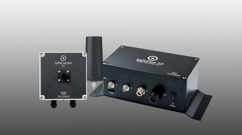
SafeCaptain P-Series
P-Series fixed navigation units integrate seamlessly with SafeCaptain software to meet diverse navigation needs.
The P1 offers stable data transfer via Wi-Fi and easy setup through a pilot plug. The P1+ enhances accuracy with advanced GNSS and anti-jamming technology. The ACP-compliant P3 is built for demanding environments, featuring dual-band GNSS, spoofing protection, an IMU for precise navigation, and a critical backup battery for uninterrupted operation during blackouts.
The P1 offers stable data transfer via Wi-Fi and easy setup through a pilot plug. The P1+ enhances accuracy with advanced GNSS and anti-jamming technology. The ACP-compliant P3 is built for demanding environments, featuring dual-band GNSS, spoofing protection, an IMU for precise navigation, and a critical backup battery for uninterrupted operation during blackouts.
Software Features
Pro navigation software
Provides
comprehensive
navigation data,
including route
planning, safety
contours, and
simulation tools
for better
decision-making
and training.
comprehensive
navigation data,
including route
planning, safety
contours, and
simulation tools
for better
decision-making
and training.
Docking & alignment
Enhanced feature for precision docking, including shoulder distance to fender lines, transverse speed, and berthing angle.
Chart annotations & distance measurement
Ability to mark specific areas directly on the chart and create custom lines to measure distances with precision.
River module
Enables quick
navigation
between multiple
locations, calculates
meeting points,
and provides speed
recommendations for efficient river navigation.
navigation
between multiple
locations, calculates
meeting points,
and provides speed
recommendations for efficient river navigation.
Under Keel Clearance (UKC)
Ensures safe passage through constrained waterways by
calculating the optimal time for transit based on water depth.
calculating the optimal time for transit based on water depth.
Live weather data
Displays real-time weather conditions, including tide, current, wave, wind, and
visibility, to improve
situational awareness.
visibility, to improve
situational awareness.
Jamming/ Spoofing alerts*
Protects navigation data integrity by alerting users to potential external data quality issues or
compromises.
*When combined with P1+ or P3.
compromises.
*When combined with P1+ or P3.
Care pack
24/7/365 hardware and software remote support for peace of mind and operational reliability.
Benefits
Real-time data
Freedom to monitor vessel position anywhere on board
Wi-Fi connectivity
Manual chart annotation
Advanced GNSS and motion sensors
Distance measuring and red-zone creation
Data export and
real-time replay
real-time replay
Displays official S-57/S-63 sea charts with dedicated overlays
Over-the-air firmware and software updates
Applications / Markets
Captains
Ship owners
RoRo
Ferries
Cruise ships
Yachts
Ship owners
RoRo
Ferries
Cruise ships
Yachts
Hardware

P1

P1+

P3

SafeCaptain Navigation System Flyer
Discover how SafeCaptain software, paired with P-Series fixed navigation units, enhances flexibility and ensures safe, efficient vessel maneuvering through narrow, complex, and congested waterways. Learn about the advanced technical specifications that make these solutions reliable and precise for even the most demanding navigation challenges.
SafePilot Brochure
Trelleborg’s navigation and piloting solutions take advantage of the latest smart technology to improve situational awareness during maneuvers and enhance the safety, efficiency and sustainability of port operations.
SafeCaptain and CAT ROT PPU integration for improved safety and efficiency
See how Trelleborg's SafeCaptain and CAT ROT PPU integration revolutionized safety, efficiency, and reliability for Arkas Holding's container fleet with real-time data sharing and precise navigation in challenging waterways.